Skip navigation links

Buy now

Please purchase all our products from these authorized dealers only to ensure that you receive full support in Warranty and replacement matters.

GPSMAP® 2108 Plus
Discontinued

GPSMAP® 2108 Plus

Part Number 010-01323-02

SHOP ONLINE

GPSMAP® 2108 Plus GPSMAP® 2108 Plus GPSMAP® 2108 Plus

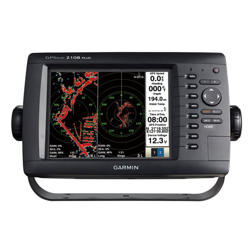
8" Keyed Chartplotter/ Radar Combo

  • With 8” SVGA sunlight-view color LCD with VGA video output
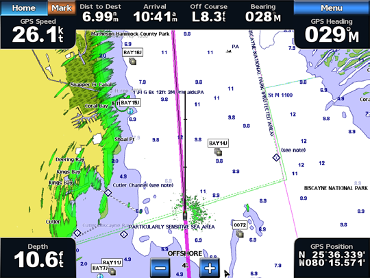
  • Preloaded worldwide base map and support Garmin BlueChart g2 vision
  • Beidou-enabled, high-sensitivity GPS/GLONASS built-in receiver
  • Supports all Garmin GMR marine radar
  • AIS overlay on the Chart page and the Radar page
  • Language support: English, Simple Chinese, Japanese, Thai, Bahasa Indonesia, Burmese

 The GPSMAP2108PLUS keyed Chartplotter/Radar combo has a 8” color SVGA display and comes preloaded with a worldwide basemap.

1 Hz GPS/GLONASS/Beidou

1 Hz GPS/GLONASS/Beidou provides position and heading updates 1 time per second (GPS antenna is required for GPS/Chart-plotter function)

Expand with Radar

Featuring a built-in radar port, GPSMAP2108PLUS can be interfaced with Garmin’s line of affordable GMR™ marine radar systems (sold separately). Whether you’re adding radar now or in the future, you’ll enjoy the convenience of plug-and-play installation as well as the power, range and high-definition targeting of our proven radar offerings. 

Networking

The GPSMAP2108PLUS offers select networking capabilities that allow you to share features with other compatible GPSMAP2108PLUS, such as radar, supplemental maps, and user data, such as waypoints, routes and tracks.

Radar Support

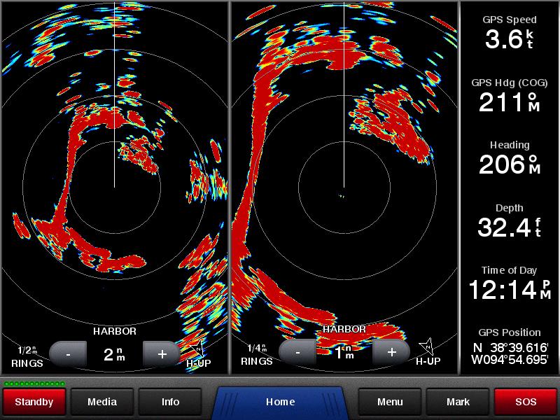
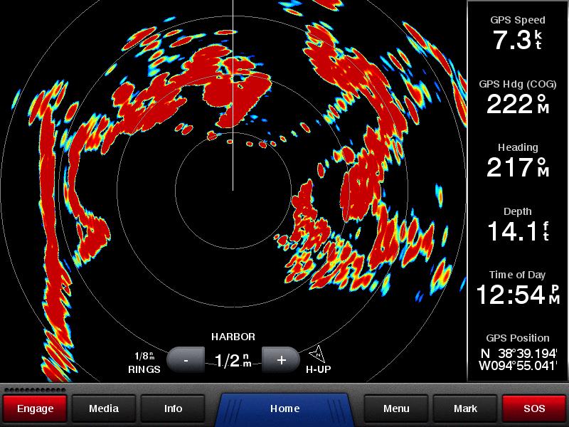
GMR xHD radar support, Dual range radar, Radar trail function, MARPA, Range ring engrave by degree, EBL/VRN range ring brightness support, Radar overlay

Dual Range Operation Dynamic Auto Gain and Sea Filter
xHD performance in a dome Radar Overlay

Physical & Performance

Unit dimensions, WxHxD 11.2”x6.7”x2.9”(28.5x17.2x93 cm)
Display size, WxH 6.8”x5.1”, 8.4”
Display resolution, WxH 800 x 600 pixels
Display type SVGA display
Weight 3.1lbs(1.4kg)
Waterproof (IPX7)
GPS Receiver 1 Hz sensitivity
GPS Antenna With external connection (BNC)
Mounting options Bail, flush
Power Supply Range 11-32 VDC
Power consumption Max power usage at 10 Vdc: 14 W
Typical current draw at 12 Vdc: 1.1 A
Max current draw at 12 Vdc: 3.2 A

Maps & Memory

Preloaded maps None
Accepts data cards 1 SD™ card
Waypoints 12,000
Routes 200 (max 250 waypints per route)
Track log 25,000 points; 100 saved tracks (max 2500 marks per tracks)

Features & Benefits

Garmin Radar compatible  
Garmin Sonar compatible  
NMEA 2000® compatible  
NMEA 0183 compatible  
Garmin Marine Network™ compatible (limit capabilities)
Garmin SmartMode compatible (customizable monitor presets)  
Supports AIS (Automatic Identification System) (NMEA0183)
Supports DSC (displays position data from DSC-capable VHF radio) (NMEA0183)
Tide tables  
GSD™ Black Box sonar support  
GCV™ Black Box sonar support  
BlueChart® Mobile (planning) compatible  
Garmin Helm compatible  
GRID™ (Garmin Remote Input Device) compatible  
Wireless remote compatible  
Wireless mouse compatible  

Connections

NMEA 0183 input ports 2
NMEA 0183 output ports 2
Video input ports None
Video output ports (D-Sub)
Wireless connectivity  
Garmin Marine Network™ ports 1 (RJ45)

In The Box

  • GPSMAP2108PLUS with worldwide basemap
  • Power/data cable
  • Bail mount
  • Protective cover
  • Documentation
 
Download the File
 

Software License Agreement

By downloading, installing, or using this software, you agree to be bound by the terms and conditions of the following license agreement. Please read this agreement carefully.

Garmin Corporation ("Garmin") grants you a limited, non-exclusive license to use the upgrade software ("Software") in binary executable form in the normal operation of the applicable Garmin products. Title, ownership rights, and intellectual property rights in and to the Software remain in Garmin. This license is personal to you and you may make copies of the software only for your personal use. You agree that this license agreement does not need to be signed for it to take effect.

The software is provided on an "as is" basis without warranty of any kind — either expressed or implied — including, without limitation, any implied warranties of merchantability or fitness for a particular purpose. Garmin does not warrant the performance of the software or that the software will meet your requirements or operate error free.

You acknowledge that this Software is the property of Garmin and is protected under United States of America copyright laws and international copyright treaties. You further acknowledge that the structure, organization, and code of the Software are valuable trade secrets of Garmin and that the Software in source code form remains a valuable trade secret of Garmin. You agree not to decompile, disassemble, modify, reverse assemble, reverse engineer, or reduce to human readable form the Software or any part thereof or create any derivative works based on the Software.

You agree not to export or re-export the Software to any country in violation of the export control laws of the United States of America.


2019/06/29

GPSMAP2108 Plus v3.00

DownloadDownload(19.6 MB)

GPSMAP2108 Plus v3.00

Release Note:

  1. Add support for the ZDA sentence


How to Update the Software?

  1. Click on 'Download' and choose to save the file to your computer.
  2. Choose a location where you can easily find the file, such as the 'My Documents' folder or 'C:\'.
  3. Once the download is complete, go to the location where you saved the file.
  4. Double-click on the downloaded file. This will automatically extract the files to C:\Garmin and run a program to transfer the software update to an SD card.
  5. Power on the device and make sure all attached network devices are powered on as well.
  6. Insert the card into the card slot of your primary device. Select 'Update Software' in the window that automatically displays. If you do not have a primary device with a card slot, please see your dealer.
  7. After the update completes, all Garmin Marine Network devices and NMEA 2000 sensors will have the latest software. This ensures all of the devices will be able to communicate with each other. Note: If you have additional chartplotters connected to NMEA 2000 and not the Garmin Marine Network, you will have to independently update each chartplotter. After the update of the Garmin Marine Network completes, insert the update card into each NMEA 2000 chartplotter.


NOTE:

This software should only be uploaded to the unit for which it is intended. If this software is uploaded to a GPS unit other than the product it is designed for, it will render the unit inoperative.
If the software upload fails, and subsequent upload attempts prove unsuccessful, the unit may need to be returned to Garmin for service. Call Garmin at +886.2.26429199 ext2 or email Garmin. You may also contact Garmin authorised dealer for product support.
Before proceeding, please back up your waypoints and route data. You may back up the data by copying the GPX files in the Garmin disk to your computer. This software should only be uploaded to the unit for which it is intended. If this software is uploaded to a GPS unit other than the product it is designed for, it will render the unit inoperative.


Change History:

Version 2.20:

  1. Go to the last viewed function after reboot unit.
  2. Not allow using BACK key to get back to home page in Chart, Sonar and Radar pages.
  3. Change Korean font.
  4. Display current position legends while panning the cursor.
  5. Extend AIS/MARPA alarm distance up to 10 miles.
  6. Display legends on "New Route" and "New Boundary" map.
  7. User can hide waypoint symbol on boundary line.
  8. Duplicate duplicate data overlay in overlay number layout settings.
  9. Translation issues.
  10. Increase the waypoints, routes and tracks memory size.
  11. Add Function Mode setting to choose "All", "Sonar Only", and "Radar Only" functions.
  12. Change default chart page as "Navigation Chart".
  13. Add a "Chart Options" in chart menu.
  14. Close the menu window after the setting is applied by "Done" button.
  15. Support keypad handling for English keyboard.
  16. Resize the full screen display window after the menu popup for chart, sonar and Radar page.
  17. Display Gain manual level or Auto word at the display bottom of the left in sonar page.
  18. Combine all radar functions into one offshore mode.
  19. Show Sea Clutter and Rain Clutter information on the left-bottom data window on Radar page.
  20. Adjust the dual range radar menu.
  21. Adjust the vessel position to center in radar overlay.
  22. Add Look Ahead Speed setting in radar overlay menu.
  23. Use the last used waypoint symbol as default when user create the new waypoint.
  24. Bugs fixing.

Version 2.10:

  1. Added Shortcut Key feature.
  2. Supported Sonar Color Rejection.
  3. Supported Dual Range Radar.
  4. Supported Radar MARPA function.
  5. Added Boundary Line feature.

back to top


Loading

Loading